
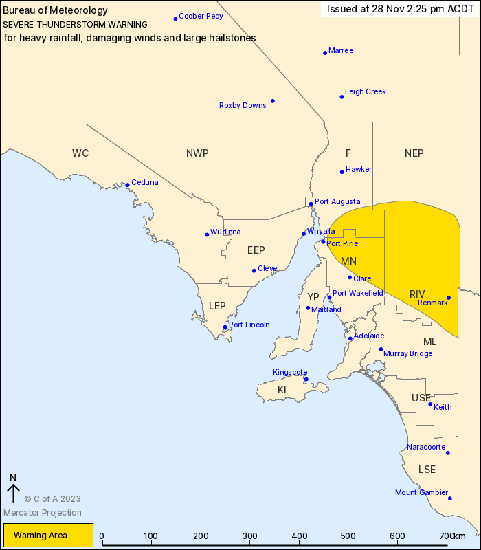
Source: Bureau of Meteorology
For people in Riverland and parts of Flinders, Mid North, North
East Pastoral and Murraylands districts.
Issued at 2:25 pm Tuesday, 28 November 2023.
Severe thunderstorms forecast to continue from Port Pirie to the
NSW and Vic border.
Weather Situation: An upper level low over South Australia is
maintaining unstable conditions with further severe thunderstorms
expected this afternoon.
Severe thunderstorms are likely to produce heavy rainfall that may
lead to flash flooding, damaging winds and large hailstones in the
warning area over the next several hours.
Locations which may be affected include Renmark, Jamestown,
Waikerie, Burra, Peterborough and Danggali Conservation Park.
Severe thunderstorms are no longer occurring in the Mount Lofty
Ranges district and the warning for this district is
CANCELLED.
Significant rainfall observations up to 08:45am:
SCOTCH COLLEGE RECORDED 45.8MM IN THE 1 HR TO 07:02AM
Kapunda (Mingays Waterhole) recorded 43.8mm in the 3 hrs to
08:01am.
Ridge Park recorded 35.2mm in the 2 hrs to 07:30am
Belair (St Johns) recorded 44.2mm in the 3 hrs to 08:51am.
Bellevue Heights recorded 46.6mm in the 3 hrs to 08:52am.
Waterloo East recorded 39.6mm in the 3 hrs to 07:53am.
Coromandel Valley recorded 40.6mm in the 3 hrs to 08:49am.
The State Emergency Service advises that people should:
* Secure or put away loose items around your property.
* Move cars under cover or away from trees.
* Keep clear of fallen power lines.
* Don't drive, ride or walk through flood water.
* Keep clear of creeks and storm drains.
* Stay indoors, away from windows, while storms are nearby.
28/Nov/2023 04:00 AM

