
Source: Bureau of Meteorology
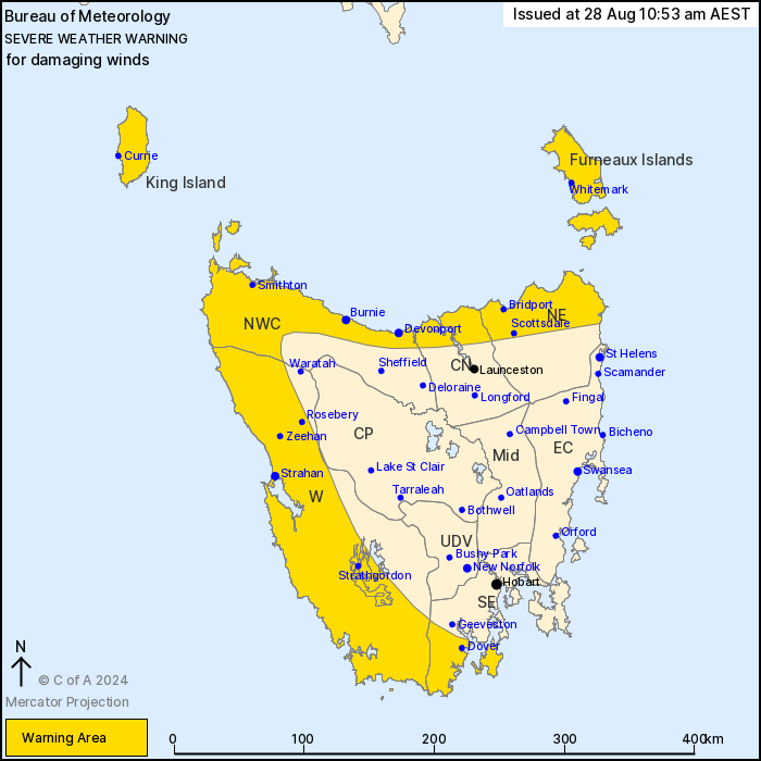
For people in King Island, Furneaux Islands, Western and parts of
South East, North East, North West Coast, Central North and Central
Plateau Forecast Districts.
Issued at 10:53 am Wednesday, 28 August 2024.
Damaging winds to continue across northern and western parts of
the state today.
Weather Situation: A series of fronts embedded in a vigorous
westerly airstream will continue to affect Tasmania today. A brief
easing is expected during Thursday.
DAMAGING WESTERLY WINDS averaging 60 to 70 km/h with peak gusts
around 100 km/h are possible over the warning area today. Gusts to
110km/h are possible across the northwest coast west of Wynyard and
also the Bass Strait Islands until later this evening, or anywhere
in the warning area associated with thunderstorms.
Winds are expected to gradually ease below severe thresholds
overnight tonight starting from the north, with southern parts of
the warning area easing Thursday morning.
Locations which may be affected include Devonport, Burnie,
Whitemark, Strahan, Queenstown and Dover.
Significant wind observations to 10:45 am AEST Wednesday
include:
Sustained 100km/h winds with a 156 km/h wind gust was recorded at
Mount Read at 5:08 am
143km/h wind gust was recorded at Kunanyi (Mount Wellington Peak)
at 8:48 am
137km/h wind gust was recorded at Low Rocky Point at 6:56 am
116km/h wind gust was recorded at Scotts Peak Dam 7:04 am
115km/h wind gust was recorded at Hartz Mountain at 8:02 am
The State Emergency Service advises that people should:
* Supervise children closely.
* Check that family and neighbours are aware of warnings.
* Manage pets and livestock.
* Secure outdoor items including furniture and play
equipment.
* Be prepared in case of power outages and report any outages to
TasNetworks on 132 004.
* Beware of damaged trees and power lines and take care when
driving.
* Listen to the ABC radio or check www.ses.tas.gov.au for further
advice.
* For emergency assistance contact the SES on 132500.
28/Aug/2024 12:58 AM

